Mountain Bike Reviews Forum banner
1 - 20 of 38 Posts

NoCanSurf

· Registered
Joined
·
864 Posts
Discussion starter · #1 ·
Aloha Internet Mountain Bike Riders!

You know me or have at least disagreed with one of my posts. I’ve got a 2023 Trek Fuel EX Gen 6, which I think is the pretty cool. I’m normally rely on my iPhone and Apple Watch for tracking my ride. I’ve tried the Cyclemeter App, which is really good, but I’m thinking I want something more roughed, durable and less of a problem if it gets busted up when I go over the bars…

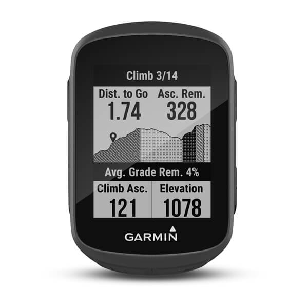
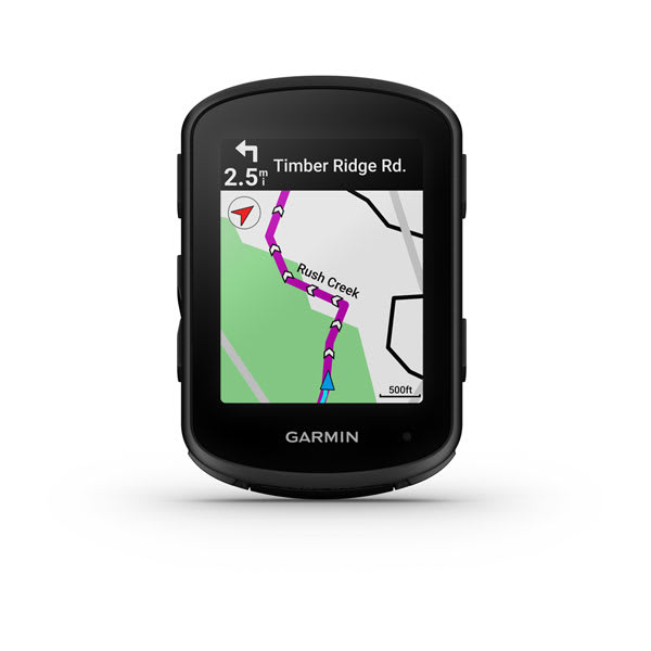
I was thinking a Garmin, Wahoo, Hammerhead or even Lezyne computer mounted to my handlebar, pointing out where to turn next, or how step this hill is, etc.

Here are a few other details…
  • I want to link the bike computer to my iPhone and Apple Watch if possible.
  • I don’t Strava and don’t plan to.
  • My bike is kitted out Shimano XT (if that matters).
  • The computer should have a reasonable price.
  • Doesn’t need a color display, gray scale is fine.
  • I might be buying Ant+/Bluetooth cadence and speeds sensors (which I want link to the Bike computer and iPhone).
  • At the time of this posting, I plan to use this computer exclusively on the Fuel.
  • But… The more I think about it, maybe the computer will find its way to my other bikes.
Image

(image used to increase engagement)​

I also want to avoid my bike computer becoming self-aware and taking over the world with a surprise nuclear attack followed by an army of chrome robots. I’m watching you AI…
 
  • Like
Reactions: flgfish
Easy and cheap to get additional mounts for the other bikes, I swap my Garmin between 5 bikes. I like Garmin, they are not cheap though. Lezyne is less expensive, has less refined connections to other 3rd party apps like RideWitheGPS, TrailForks, Kamoots, etc…. Wahoo is OK, somewhat basic screen map display. Hammerhead is very refined, just has crappy battery life at around 12 hrs, and no direct connection to TrailForks. If you do not need a lot of performance metrics like power, and other items, the Garmin Edge Explore 2 is $250 or so, maybe $300. Is a bigger unit, does a good job displaying maps, color on map is essential, better defines what info you are looking at and pretty much all the units hve color maps this point,
 
What do you want the link to your phone to actually do?

Many can connect to your phone via bluetooth, but this is done for specific functions. I only use it for uploading rides and only occasionally. So I leave the connection off (to save on battery for both devices) unless I'm specifically uploading a ride.

I tried the connection once for weather alerts and wasn't thrilled with how that turned out. I saw the sky getting gnarly before the devices started feeding any alerts.

What is a "reasonable price"? Judging by your bike, I'd guess your reasonable price is higher than mine. But impressions based on stuff like that can be wrong.

Why would you link your sensors to both the gps and the phone? If you're using the bike computer to record your ride and give you information, just link the sensors to the bike computer. The phone doesn't need that information. Not to mention, many sensors will not output to 2 different devices at the same time.
 
Garmins use a phone app called Connect Mobile. It BT connects to the cycling device, grabs a completed ride data and sends it up to the Garmin Connect website and if you choose, up to a different activity tracker like Strava, RWGPS, etc, Wahoo works the same way. They can also port over software updates amd are used to get navigable routes sent to the device. Hammerhead uses WiFi directly, can use a SIM card, or a phone hotspot, there’s no on phone app for Hammerhead,
 
You’re feeling the need for some retail therapy?

What exactly do you expect to do with a screen?

don’t you already have enough screens? Maybe mtb time can be your chance to be in the world.

;)
 
  • Like
Reactions: fredcook and Ezra E
You can always just get something basic like a Garmin Edge 130. It can pair with your iPhone through Garmin Connect and can also connect to other Ant+ devices. I use a Garmin Instinct watch...and its paired with my phone.

 
Garmin Edge, highest number you can afford or want to spend. I mount mine on my mtb w/ a K-edge “gravity cap” mount, out of the way and super secure. Swap it to a handlebar mount on my gravel bike.

only complaint I have about my 530 is the elevation is always off, especially if it gets wet/humid - not ideal in here in Hawaii! I think that may be improved in newer models.

The Wahoos look nice but no personal experience.
 
Discussion starter · #10 ·
What do you want the link to your phone to actually do?
I was thinking I'd upload trail maps.

The Apple Watch capture all the details I can manage. I'm not at the point in my life were I need power numbers and what not. I just like to see my ride, and boost about how cool I am.

What exactly do you expect to do with a screen?
The map is the big deal. When out on the MTB, I don't need to know how fast I am or my power output. I need the map and/or the went it time to turn. That data is nice for road rides, but I in the woods its the fun that matter most to me. I guess that's type 1 fun, while road riding is more a type 2 fun.

Also, if it's not on Strava, it didn't happen.
I know.
 
  • Like
Reactions: noapathy
I've used Garmin and Wahoo.

It's been 6-7 years since I used a Garmin, so my knowledge of their software might be out of date, so YMMV.

Garmin's software on your computer is bloated and kludgy - you have to install multiple apps, some of them want to run in the background all the time, the UI is clunky. But it works, and is comprehensive and full-featured. It also syncs to the computer and all the social services. It's more expensive, but you're basically getting into an ecosystem, and that has benefits.

Wahoo puts the whole UI onto their mobile app, which is clean, easy to use, and minimal. So, configuring the unit on the bike you go through the phone, which is easier and better. It integrates with the various social things (i.e. Strava) the same as a Garmin, but getting the files to your PC requires going in to the unit like a USB drive and grabbing them manually. [Edit: this is wrong, see WER304's post on page 2] The only desktop app available has a paid subscription, for training programs.

I think Garmin is worth the price if you want a one-stop shop that does it all, but Wahoo is worth it if you want to integrate it in to 3rd party apps that you prefer using now. Like, I use an app called 'rubiTrack Pro' to manage my saved gpx files on my Mac, because I prefer the UI.

If I go on another long-term bike tour, like 6+ months, I'll look at my options again - I think the Garmin package may be superior for that - but for the trail riding and bikepacking I do now, the Wahoo is sufficient.
 
You haven't really said what you want it for but my recommendation would probably still be the same whatever.

I'd suggest the Garmin Edge 840.

I've had a Garmin Edge 1000 (touch screen and not recommended) and currently use a Garmin Edge 530 (buttons are OK but I want buttons and touchscreen).

The 840 has both buttons, a touchscreen and a fast operation. For navigation, the touch screen is really useful for scrolling the map. Scrolling a map with buttons gets tedious very fast.

When riding though the buttons are really useful to change screens, etc. quickly especially when it's raining. My old touchscreen used to lock up when that happened. Generally a UI based on touch is a pain in the arse when you're moving.

I've used mine for long multi-day tours, bike packing and overnight rides. If you put it into battery saver mode you can get really long run times.

The modern Edges have a nice fast UI, fast route planning and long battery life. They're much more reliable than older models and worth the money IMHO.
 
I use a Garmin 840. I like the flow, grit, and cycling dynamics info specific to MTB. Cycling dynamics is data about your jumps, air time, distance.


The compact size of the 840 works well with a stem tube mount.


I also use the 840 with my Tacx trainer and road bike. You can create a profile for each of your bike to really hone in on the different info the particular bike can provide.

It handles ANT+ sensors easily.

My wife uses a 1040, it's the size of a small cell phone. One feature I really like is the group ride, it shows me where my wife is on the map. This gives me peace of mind.
 
I was thinking I'd upload trail maps.

The Apple Watch capture all the details I can manage. I'm not at the point in my life were I need power numbers and what not. I just like to see my ride, and boost about how cool I am.


The map is the big deal. When out on the MTB, I don't need to know how fast I am or my power output. I need the map and/or the went it time to turn. That data is nice for road rides, but I in the woods its the fun that matter most to me. I guess that's type 1 fun, while road riding is more a type 2 fun.
That’s the rub for me. Have you tried reading trail maps on those tiny screens? When I really need to navigate I’ve got the phone and an offline map app, or even a photo of a topo.

I understand having a map readily available is important in some situations, for example if you’re racing an unmarked course, but just riding along a tiny bike computer is another piece of gear you don’t need.

At least try before you buy - I was actually shocked how bad they are for the money.
 
I was thinking I'd upload trail maps.

The Apple Watch capture all the details I can manage. I'm not at the point in my life were I need power numbers and what not. I just like to see my ride, and boost about how cool I am.


The map is the big deal. When out on the MTB, I don't need to know how fast I am or my power output. I need the map and/or the went it time to turn. That data is nice for road rides, but I in the woods its the fun that matter most to me. I guess that's type 1 fun, while road riding is more a type 2 fun.
When you say "trail maps", what exactly do you mean? If you're referring to the trails themselves, there are certain, specific ways you can get specific routes to show up via a phone connection. I don't know all the details because I don't use mine this way. If you mean reference maps that show an entire network of trails and the terrain and roads and whatnot around it in case you need to make route adjustments on the fly, no, you won't be loading those onto your device with a phone connection. Some computers will have some level of reference map like that preloaded (which may or may not be useful), but if you want to add layers (such as a trail network layer) to it or replace it, then you're going to need a computer to connect to.

I use a Garmin watch and/or a phone app to record my rides, but I never look at either one during a ride. I still use paper maps to tell me where to turn when in unfamiliar areas.
I have a basemap of my region loaded onto mine, but yeah, I very very rarely look at it. I, too, use paper maps when good ones are available and if not, will pull use my phone. And that doesn't involve connecting my phone to my bike computer in any way.

The maps on my device really only come into play if I program a route onto the computer so I'm getting navigation prompts. I program routes in such that I don't need reference maps (turn prompts are programmed into the "course" file in garmin parlance), but those reference maps are sometimes handy for that purpose.
 
Garmin Edge, highest number you can afford or want to spend. I mount mine on my mtb w/ a K-edge “gravity cap” mount, out of the way and super secure. Swap it to a handlebar mount on my gravel bike.

only complaint I have about my 530 is the elevation is always off, especially if it gets wet/humid - not ideal in here in Hawaii! I think that may be improved in newer models.

The Wahoos look nice but no personal experience.
I find the 530 is the sweet spot on price & features. I don't particularly like the touch screen and they are problematic with certain weather, gloves, etc.

You are very right with the elevation data. I live in a humid area of south LA and thunderstorms do weird things to the barometer (which is what Garmin uses for elev. calculations). I'm a remote sensing scientist and deal with GPS/GNSS daily, I haven't understood why Garmin doesn't use published elev. data (like Google Earth, etc.) My only conclusion with GPS devices for fitness activities, is the data doesn't have to be super-accurate on the horizontal and vertical (because none of it is).
I mean, they do use that published data. It's used by pretty much all of the online services for their elevation corrections. So if your barometric altimeter goes wonky due to weather, just tell Garmin Connect or Strava or whatever to apply elevation corrections. It's not hosted on the device because of the massive storage space it'd require. I'm sure you've got a concept of how much that'd take.

Still, those elevation databases they use can only have a resolution so high to be useful for our purposes. Sure, super high-res elevation data (obtained from LiDAR) is available for a LOT of places nowadays. But since using that stuff for our uses depends heavily on positional accuracy of our recorded track, which you acknowledge has its limitations, using elevation models with an exceedingly high resolution is likely to introduce a ton of error.
 
1 - 20 of 38 Posts